Project Break and Reanalysis
Day four marked a break in the project schedule. Cameron headed into town to take care of some administrative business, access the internet, pick up supplies, and further evaluate the radar images. Bruce and William headed out to the jungle for some more traditional reconnaissance and to explore the medicinal plants, insects, and animals of the jungle. (Bruce writes about this in his update for kids.)
Using the points that the group had ground-truthed as a guide, Cameron rechecked the Star3i data in hopes of better understanding which of the ten remaining points of the original 16 would be likely to yield the best sinkhole features, and to see if there were any other possible sinkhole points. As the sinkhole for Actun Yaxteel Ahau was used to inform our initial visual analysis of the radar images, we had been predominantly locating features with a similar topography--depressions within valleys or areas carved by water runoff. Since point 4 is the one point that most closely resembles the type of sinkhole formation we are looking for, Cameron decided to search for other points like it in the radar image and to compare it to the ten remaining points.
This informed analysis indicated that points 3, 15, and 16 were our best bets out of all the points, and that points 1, 2, 6, 7, 8, 9, and 10 were not likely to yield sinkhole features (slightly different from what we thought before). As they all fell within the same general area, we decided we would visit points 1, 2, and 3 in one day. This would allow us to check out point 3, as well as make sure points 1 and 2 were really not the types of features for which we were looking.
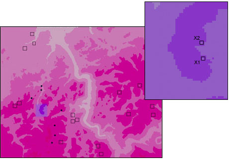
The new analysis also yielded six new possible sinkhole locations. Designated points X1 through X6, these new points seemed likely to be actual sinkhole features. We decided to add them to the list and check them out in the upcoming days (see points X1 and X2, left).
The main problem that faced us with the remaining good prospects out of the initial 16 was gaining access to points 15 and 16. Cameron went back to speak with the landowner, who said he was not keen on the idea, but that the decision wasn't entirely up to him, as he and his two brothers had agreed to discuss such matters as a group. If his brothers agreed to the idea, he would go along with it. Cameron then went to talk to the two brothers about the project and the plan to check out the possible sinkholes. One brother was opposed to the idea on the grounds that he didn't see any long-term financial benefit for his brother if we were to be given access to the land. The other brother was in favor of the idea, and indicated that yes, there were two sinkholes in the area with artifacts inside, as well as a cave that they had been taking tourists to visit. With the vote 2 to 1 against the plan we decided to table the idea for this mission, and perhaps try again in a future endeavor to visit points 15 and 16.
William and Bruce returned from the jungle tired and extremely dirty. They had located a small cave on the side of a mountain relatively close to Actun Chapat. The small cave had evidence of Maya utilization in the form of a large platform and possible reset spleleothem formations. We decided to revisit this cave later in the week, on day seven.


