Getting Ready for Our Expedition
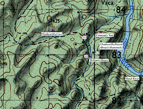
Prior to the mission we got together and plotted the points for the possible sinkhole locations gathered from our Star3i RADAR data onto the British Department of Survey (DOS) maps (see map above for a subset of one of these). After plotting the points, we noticed that some of the possible sinkholes were very close to our base camp and some were far away in the deep jungle. Based on our previous work in this area, William's extensive knowledge of the region (his extended backyard), and our analysis of the DOS maps, we surmised that some of the points were unlikely candidates and some appeared to be quite promising. We categorized the points as follows:
Promising (most likely to be sinkhole features):
Close: points 4, 5, 14, 15, 16
Far: points 1, 2, 3, 6, 10
Not so promising (unlikely to be sinkhole features):
Close: points 11, 12, 13 (see map)
Far: points 7, 8, 9
We decided that we would attempt to visit all of the closest points first--both promising and unlikely candidates--to cover as many as possible at the start of the survey, then focus on the most promising distant points.
We programmed the coordinates for all of the points into the GPS. Having done this, we can select a point and the GPS will indicate the distance and compass direction of the point from wherever we are. As we walk in the direction of the point, the GPS should begin counting down how many meters away we are. When the count hits 0 meters, provided our coordinates are accurate and the GPS satellite signal is strong, we should be standing directly on the point in question.
Although our permit (granted to Jaime Awe by the Belize Department of Archaeology) allows us to explore cave sites in the region, we are committed to contacting landowners in advance for their permission to check possible sinkholes. William took care of this for points 4, 5, 11, 12, and 13 by contacting his parents, a neighbor, a good friend, and himself (one of the points falls on his property). Cameron went to talk with the individual whose land most likely encompasses points 15 and 16. The landowner indicated that he was not interested in granting access to his property. However, he did say that an arrangement might be reached at some point, but that Cameron would have to come back later in the week to discuss it further.


