Introduction
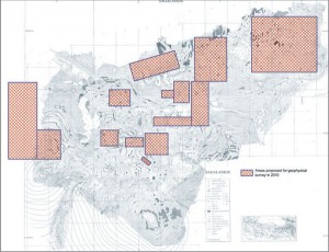
Since 2002 the urban area of Sagalassos is surveyed with various geophysical techniques with excellent results. We would like to continue this research during the 2010 campaign in a selected number of areas.
Aims & Methodology
As a measure of preparation the application of geophysical techniques at the site may involve the clearance of surface vegetation in some areas. In addition, geophysical survey around the sites under excavation may help resolve specific research questions.
1. The research on the urban water network
The geophysical survey techniques applied at Sagalassos since 2002 proved to generate highly useful information for the reconstruction of the urban planning and the urban infrastructure (the water network and network of streets). For the reconstruction of this network, past research has proven it to be highly useful that built water channels, detected at the excavated sites, are investigated and further traced with geophysical techniques. We would therefore like to maintain the same approach during the 2010 campaign. This investigation also may involve the cleaning of sediments of some previously exavated water channels.
2. The eastern residential area and Potters’ Quarter
The eastern residential area and Potters’ Quarter of Sagalassos were investigated in the past with various geophysical techniques (magnetometry, GPR with 200 and 400 MHz antenna, etc.). As some research-specific questions remain, some additional profiles may be useful in these zones.
3. The study of the course of the late Roman (?) fortification wall
During the transition of the 4th to the 5th century AD, the town centre of Sagalassos was refortified. To verify the reconstructed circuit of this wall geophysical survey would be useful among others in the north eastern part of the walled circuit. This area should also be surveyed to trace other subterranean structures preserved in this zone.
4. The area south and east of the Upper Agora
In preparation of the visual enhancement of the area around the Upper Agora, it would be useful to survey the unexcavated zones to the east and south of the Agora. This will allow a better understanding of the structural remains buried here, which will assist in assessing the research potential and planning the excavations of this zone.
5. The area south and east of the Macellum
Within the framework of the architectural reconstruction of this building and to understand its position within the urban plan (a.o. its accessibility), it would be useful to investigate the unexplored areas east and south of this building with geophysical techniques.
6. The area south of the Lower Agora, adjacent to the north-south colonnaded street
Archaeological and architectural survey in the area to the south of the Lower Agora revealed a number of regularly planned structures oriented towards the monumental artery to the east and a parallel secondary street to the west. Especially also because of the suitable terrain conditions here, it would be highly useful to further explore the structural evidence in this area with geophysical techniques.
7. The areas north, south and east of the Roman Baths
Recent excavations within and south of this bathing complex offered valuable evidence concerning earlier building phases of this otherwise 2nd century A.D. building. To obtain more insight into the organization of the still unexcavated parts (especially the east wing, but also the areas to the south and north), it would be useful that these zones would be explored with geophysical techniques.
8. The area around the urban villa under excavation
The excavations since 1995 of the urban villa “Domestic Area” have demonstrated the exceptional dimensions of this mansion. Geophysical survey within and around the excavated area will allow a better understanding of the organization and boundaries of this villa. In addition, GPR survey within the building also will assist the study of the water network of this house.
9. The area west of the western necropolis
The monumental centre of Sagalassos expanded in Imperial times beyond the Hellenistic walled circuit. Hereby the necropoleis likely bounded the inhabited urban area. Geophysical survey on the highly suitable terrain to the west of the western necropolis should shed more light on the functional use of this zone – in comparison to the “urban core area” – and on the density and character of its occupation.
10. The southern half of the western domestic quarter and the area around the test sounding WDA
Since 2008 the surface architecture of the western residential area is mapped in addition to the geophysical survey carry out here. Despite of the rugged terrain conditions, this survey offered promising results, allowing a better understanding of the spatial organization of this housing area. The 2010 field work will therefore follow the same approach, whereby the results of the geophysical survey will greatly assist the interpretation of the results of small test soundings, which we would like to carry out in a selected area in the southern half of this western residential area. Simultaneously, geophysical survey around the area of the WDA test sounding, dug in 2009 in the northern part of this residential zone, will offer a better spatial framework to interpret the wall structures excavated in this trench.
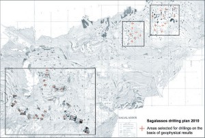
Finally, for geophysical purposes, we would also like to plan drillings on the investigated terraces of the western residential area, and possibly some drillings also at eastern residential area and Potters’ Quarter. This approach should inform us on post-occupational soil formation processes or terracing activities and should instruct us on the formation of cultural horizons and the deposit stratification.
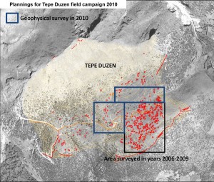
At Tepe Duzen, a site partly contemporary with Sagalassos, 1.8km SW of Sagalassos geophysical research will be continued as well. Between 2006 and 2009 a large part of the plateau was surveyed with the magnetic method and/or GPR, with excellent results showing the possible layout of the settlement and with the potential to predict areas suitable for archaeological excavations. In 2010, the geophysical survey will be continued to the north and west of the previously surveyed area. Apart from those areas, geophysical survey may also be required to further investigate previously surveyed areas that will be subject to archaeological test soundings.
Lastly, for geophysical purposes, drillings are planned on different locations on the plateau and terraces in order to study the buried archaeological and geological layers and their possible influence on the results of geophysical survey. The exact location of these drillings will be determined after all the results of the 2009 campaign have been processed.
 |
 |
For more, see www.sagalassos.be/en/webreports/2010.


